What do the data labels mean?
The RealTraffic radar display shows many data labels beyond the basic callsign and altitude. Depending on which part of the world you're flying in, there are more (or fewer) additional data fields supplied by the ADS-B messages. The depth of information provided also depends on the type of transmitter — you won't find autopilot status in an old, small GA aircraft. But most reasonably modern airframes provide a lot more information than your usual flight tracking website might suggest.
Example 1: Virgin Australia 737-800 descending
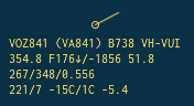
1st line: ICAO Callsign, (IATA Callsign), ICAO Type, Aircraft Registration
2nd line: Ground speed in knots, Flight level descending @ 1865 ft/min, distance from you in NM
3rd line: IAS / TAS / Mach
4th line: Wind 7 kts from 221°, SAT (OAT) −15°C, TAT 1°C, receiver signal strength (arbitrary dB scale)
Altitude is displayed in flight levels (F) if above the nearest airport's transition altitude. Otherwise it is displayed in feet and pressure-corrected using the currently valid QNH.
Example 2: Military Orion P8 at low level
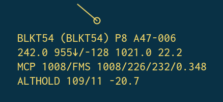
1st line: Same as above.
2nd line: Ground speed in knots, altitude in feet, vertical speed in ft/min, QNH set by the pilots, distance in NM.
3rd line: MCP altitude set to 1008 ft, FMS altitude also 1008 ft, then IAS / TAS / Mach.
4th line: Autopilot in altitude hold mode. Wind from 109° at 11 kts. Receiver signal strength.
Example 3: Air New Zealand 787 climbing out of Sydney
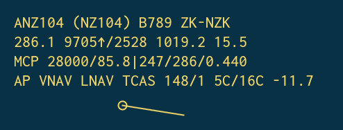
Same data fields as above, but the autopilot is in LNAV and VNAV mode, and TCAS is active.
Where does this data come from?
These additional datapoints come from a special message subcategory in the ADS-B specification. They are interrogated by air traffic control (ATC) and do not automatically broadcast, which is why you don't see them everywhere. In the Americas you rarely see the autopilot status, but in most other regions the MCP and FMS altitudes are interrogated. This helps ATC verify the pilots have set the assigned altitudes correctly.